Wrocław
What is in the archive
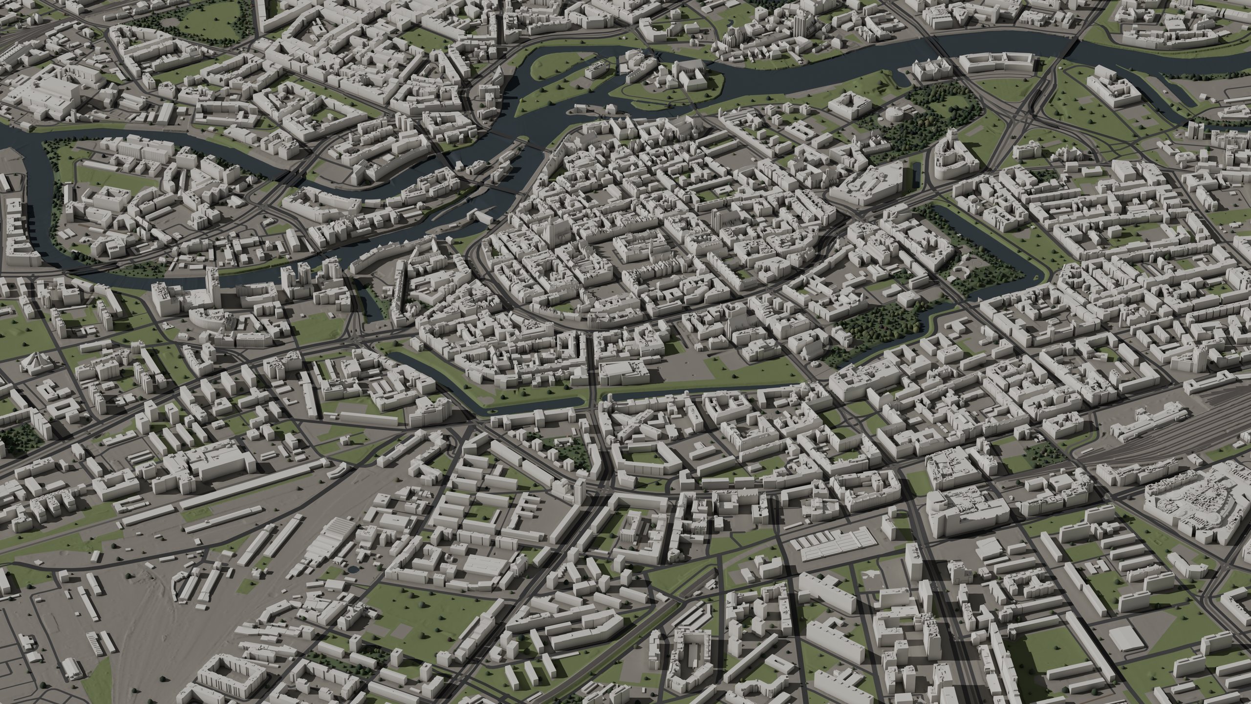
7,548 buildings at LOD2.2, plus terrain, vegetation, orthophoto and centrelines across 16 km². The buildings were reconstructed from the 2024 national LiDAR campaign at 12 pts/m². All data except 3D Tiles is stored in EPSG:2180. The bundled README covers units, the georeferencing specification and import into Unreal Engine, Cesium, DCC tools and GIS.
- README.mdUnits, the georeferencing contract, import routes for Unreal Engine, Cesium, DCC tools and GIS.12 KB
- LICENSE.mdThe licence for this pack, the same text as on this page.3 KB
- LICENSE.pl.mdThe Polish text of the licence for this pack.3 KB
- CREDITS.mdSource attribution, survey vintage per sheet.3 KB
- CREDITS.pl.mdThe Polish text of the source attribution.3 KB
- NOTICES.mdData sources and the access basis for each.2 KB
- data-dictionary.mdAn explanation of every building attribute.11 KB
- georeference.jsonMachine-readable georeferencing contract: EPSG:2180 anchor, vertical datum, units, cell grid.3 KB
- manifest.jsonPack id, source vintages, per-layer file lists, quality metrics.118 KB
usd/A single-file scene covering the full extent.82 files · 254 MB
- pack.usdaReferences every cell with its offset; one file opens the full extent.22 KB
- cells/<cell>/cell.usdaThe cell's stage, referencing its ground and building layers.×16 · 564 KB
- cells/<cell>/ground.usdcGround mesh per cell.×16 · 213 MB
- cells/<cell>/lod12.usdcBuildings at LOD1.2, block models.×16 · 8 MB
- cells/<cell>/lod13.usdcBuildings at LOD1.3, block models with height steps.×16 · 11 MB
- cells/<cell>/lod22.usdcBuildings at LOD2.2, roof shapes from LiDAR.×16 · 21 MB
- shared/materials.usdaMaterials shared across cells.8 KB
3dtiles/Streaming buildings for Cesium and web viewers.63 files · 28 MB
- tileset.jsonEntry point for any 3D Tiles 1.1 client.14 KB
- t/<tile>.glbGLB tile payloads, quadtree.×61 · 28 MB
- metadata/cjindex-metadata.city.jsonTileset metadata.1 KB
cityjson/Buildings with full attributes, all LoDs, EPSG:2180.8 files · 67 MB
- <tile>.city.jsonlCityJSONSeq, one feature per line.×8 · 67 MB
fbx/Per-cell meshes, binary FBX, cell-local origins.64 files · 310 MB
- …_<cell>_GROUND.fbxGround mesh; roads, rail, water and vegetation as material regions.×16 · 204 MB
- …_<cell>_LOD12.fbxBuildings at LOD1.2, block models.×16 · 28 MB
- …_<cell>_LOD13.fbxBuildings at LOD1.3, block models with height steps.×16 · 32 MB
- …_<cell>_LOD22.fbxBuildings at LOD2.2, roof shapes from LiDAR.×16 · 46 MB
obj/The same meshes as OBJ, with MTL companions.81 files · 681 MB
- materials.mtlShared material library.1 KB
- …_<cell>_GROUND.objGround mesh; roads, rail, water and vegetation as material regions.×16 · 631 MB
- …_<cell>_GROUND.mtlMaterial-region definitions for the ground mesh.×16 · 38 KB
- …_<cell>_LOD12.objBuildings at LOD1.2, block models.×16 · 9 MB
- …_<cell>_LOD13.objBuildings at LOD1.3, block models with height steps.×16 · 13 MB
- …_<cell>_LOD22.objBuildings at LOD2.2, roof shapes from LiDAR.×16 · 28 MB
glb/The same meshes in binary glTF format.81 files · 352 MB
- materials.jsonMaterial slot names and base tints.3 KB
- …_<cell>_GROUND.glbGround mesh; roads, rail, water and vegetation as material regions.×16 · 174 MB
- …_<cell>_GROUND_PROXY.glbSimplified ground proxy with a 4 m error budget, for fast previews.×16 · 14 MB
- …_<cell>_LOD12.glbBuildings at LOD1.2, block models.×16 · 36 MB
- …_<cell>_LOD13.glbBuildings at LOD1.3, block models with height steps.×16 · 46 MB
- …_<cell>_LOD22.glbBuildings at LOD2.2, roof shapes from LiDAR.×16 · 83 MB
heightmaps/Terrain heightfield, 1 m grid, per cell.17 files · 12 MB
- terrain_<cell>.png16-bit PNG per cell.×16 · 12 MB
- heightmaps.jsonDecode window (height floor and span) and cell layout.7 KB
masks/Per-class coverage rasters, 1 m grid, per cell.81 files · 901 KB
- terrain_<cell>_roads.pngRoads.×16 · 423 KB
- terrain_<cell>_rail.pngRail.×16 · 64 KB
- terrain_<cell>_tram.pngTram tracks.×16 · 103 KB
- terrain_<cell>_water.pngWater.×16 · 59 KB
- terrain_<cell>_vegetation.pngVegetation.×16 · 237 KB
- masks.jsonCell layout sidecar.14 KB
ortho/National orthophoto, EPSG:2180, cloud-optimised GeoTIFF.64 files · 2.08 GB
- ortho_<cell>.tifOne GeoTIFF per tile.×64 · 2.08 GB
lidar/Classified airborne LiDAR point cloud, COPC-organised LAZ, EPSG:2180.15 files · 3.21 GB
- lidar_<cell>.copc.lazOne COPC file per 2048 m point-cloud tile.×15 · 3.21 GB
vectors/3D road and rail centrelines, with elevations sampled from the included surfaces.5 files · 23 MB
- centrelines.gpkgGeoPackage, EPSG:2180.5 MB
- centrelines_roads.fgbFlatGeobuf, roads.5 MB
- centrelines_rail.fgbFlatGeobuf, rail.760 KB
- centrelines_local.geojsonCell-local coordinate frame for use in engines.12 MB
- centrelines.jsonAttribute dictionary and notes on elevation sources.13 KB
trees/Tree instances per cell: position, height and canopy tint.16 files · 406 KB
- trees_<cell>.jsonOne JSON file per cell.×16 · 406 KB
roof_tints/Roof colour per building, keyed by the object names in the meshes.16 files · 484 KB
- roof_tints_<cell>.jsonOne JSON file per cell.×16 · 484 KB
previews/Preview renders of the pack, 2560 px wide.10 files · 9 MB
- …_<shot>_web_2560.jpgOne JPEG per view.×10 · 9 MB
The text is included in the archive as LICENSE.md; a copy appears below for review before downloading.
Ontic Cities: Pack License, version 0.1
1. The deal. Buying this pack gives you (one person, or one organization and its employees/contractors working on its projects) a non-exclusive, perpetual, worldwide, royalty-free license to use it as below. You don't own the files; you own what you build with them.
2. You may: use, modify, and combine the assets and data in any number of end products — games, film/TV/VFX, stills and renders, architectural visualization, simulation and training, VR/AR, interactive experiences, broadcast, print — commercial or not; distribute them inside those end products in compiled or otherwise non-extractable form; and let contractors work with the files on your projects under these same terms.
3. You may not: redistribute, resell, sublicense, or publicly host the files or the data as files or data (raw, converted, or trivially modified); ship any product from which the meshes, heightmaps, imagery, or vector data can be extracted in usable form; use the pack to build or seed a competing dataset, asset library, or map product; or use the pack as training data for a generative-AI model made available to third parties.
4. Attribution. End products do not require an on-screen credit. Keep CREDITS.md and NOTICES.md alongside the files wherever the files themselves travel. If your published product reproduces the source imagery substantially (e.g. the orthophoto visible as a map or texture), include the data credit from CREDITS.md in your product's credits or documentation where practicable.
5. Source data. The pack is derived from Polish public geodata: datasets of the national geodetic and cartographic resource provided by the Head Office of Geodesy and Cartography (GUGiK), processed by Ontic Cities. The source authorities are not responsible for, and do not endorse, this processed content. The pack contains no personal data. Survey vintages and retrieval dates are stated in manifest.json and CREDITS.md.
6. No warranty. The pack is provided "as is". Geometry and imagery derive from public survey data with the stated vintages; no warranty of positional accuracy, completeness, currency, or fitness for a particular purpose. 7. Liability is capped at the amount you paid. 8. The license ends if you materially breach it and don't cure within 30 days of notice; sections 4–7 survive. 9. Where a marketplace's own license governs your purchase, that license controls and this document is informational.
The text is included in the archive as CREDITS.md; the access basis for each source is stated in NOTICES.md.
Credits and attribution
Contains processed public-sector data from the Polish national geodetic and cartographic resource: orthophoto imagery, LiDAR point clouds, NMT elevation models, and BDOT10k topographic data provided by the Head Office of Geodesy and Cartography (Główny Urząd Geodezji i Kartografii, GUGiK). The source data has been processed by Ontic Cities; the source authorities bear no responsibility for the processed content.
Source survey vintages
| Layer | Campaign / vintage | Detail |
|---|---|---|
| LiDAR point cloud | 2024 (index publication year) | GUGiK series 79805, 12 pts/m² nominal, 64 sheets |
| Orthophoto | 2025 | 5 cm GSD, RGB, 54 sheets: 6.148.12.02.1 (2025); 6.148.12.02.2 (2025); 6.148.12.02.3 (2025); 6.148.12.02.4 (2025); 6.148.12.03.1 (2025); 6.148.12.03.2 (2025); 6.148.12.03.3 (2025); 6.148.12.03.4 (2025); 6.148.12.04.1 (2025); 6.148.12.04.2 (2025); 6.148.12.04.3 (2025); 6.148.12.04.4 (2025); 6.148.12.07.1 (2025); 6.148.12.07.2 (2025); 6.148.12.07.3 (2025); 6.148.12.07.4 (2025); 6.148.12.08.1 (2025); 6.148.12.08.2 (2025); 6.148.12.08.3 (2025); 6.148.12.08.4 (2025); 6.148.12.09.1 (2025); 6.148.12.09.2 (2025); 6.148.12.09.3 (2025); 6.148.12.09.4 (2025); 6.148.12.12.1 (2025); 6.148.12.12.2 (2025); 6.148.12.12.3 (2025); 6.148.12.12.4 (2025); 6.148.12.13.1 (2025); 6.148.12.13.2 (2025); 6.148.12.13.3 (2025); 6.148.12.13.4 (2025); 6.148.12.14.1 (2025); 6.148.12.14.2 (2025); 6.148.12.14.3 (2025); 6.148.12.14.4 (2025); 6.149.12.17.3 (2025); 6.149.12.17.4 (2025); 6.149.12.18.3 (2025); 6.149.12.18.4 (2025); 6.149.12.19.3 (2025); 6.149.12.19.4 (2025); 6.149.12.22.1 (2025); 6.149.12.22.2 (2025); 6.149.12.22.3 (2025); 6.149.12.22.4 (2025); 6.149.12.23.1 (2025); 6.149.12.23.2 (2025); 6.149.12.23.3 (2025); 6.149.12.23.4 (2025); 6.149.12.24.1 (2025); 6.149.12.24.2 (2025); 6.149.12.24.3 (2025); 6.149.12.24.4 (2025) |
| NMT elevation model | 2025 | 60 sheets, per-sheet years in manifest.json |
| BDOT10k (building footprints, roads, rail, water, vegetation, nature points) | continuously maintained | powiat TERYT 0264, state as retrieved |
Retrieval dates
- BDOT10k, LiDAR point cloud, NMT elevation model, Orthophoto, egib: 2026-08-14
Polish attribution (dla listingów polskojęzycznych)
Zawiera przetworzone dane państwowego zasobu geodezyjnego i kartograficznego udostępnione przez Główny Urząd Geodezji i Kartografii (GUGiK). Dane źródłowe zostały przetworzone; organy udostępniające nie ponoszą odpowiedzialności za treść przetworzoną.
Questions about the pack: hello@ontic.city